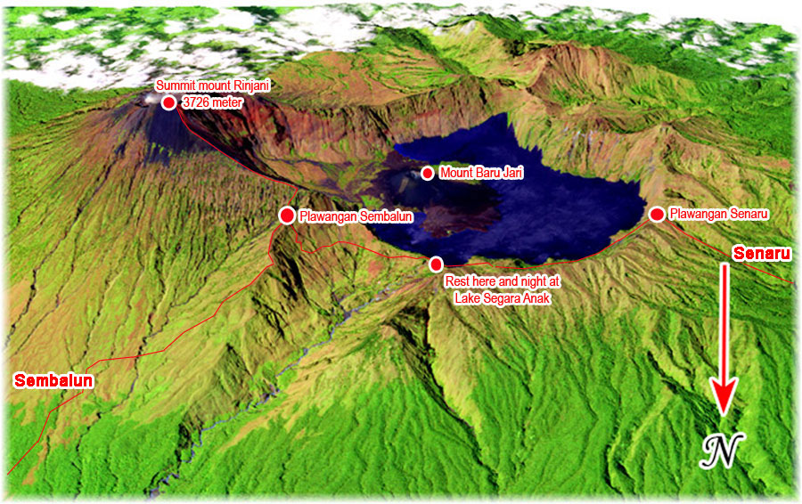
Mount Rinjani is an active volcano in Indonesia on the island of Lombok. Administratively, this mountain is located in North Lombok Regency, West Nusa Tenggara (Indonesian: West Nusa Tenggara, NTB). Soaring 3,726 meters (12,224 feet) high, making it the second highest volcano in Indonesia. At the top of the volcano lies a caldera measuring 6 by 8.5 kilometers (3.7 by 5.3 miles), partially filled by a crater lake. Known as Segara Anak or means (sea child) because of the color of the blue lake water as sea. The lake is about 2,000 meters (6,600 feet) above sea level and is estimated to be about 200 meters (660 feet) deep. The caldera also contains hot springs. The Sasak and Hindu tribes consider lakes and mountains sacred and some religious activities are sometimes carried out in these two areas.
Mount Rinjani (Indonesian: Gunung Rinjani) is an active volcano located on the island of Lombok in Indonesia.
– Elevation: Mount Rinjani rises to an impressive 3,726 meters (12,224 feet), making it the second highest volcano in Indonesia.
– Location: Administratively, the mountain is in the Regency of North Lombok, West Nusa Tenggara (NTB). It is also the highest point in the Indonesian province of West Nusa Tenggara.
– Caldera and Crater Lake: Adjacent to the volcano is a 6-by-8.5-kilometer (3.7 by 5.3 miles) caldera, partially filled by a stunning crater lake known as Segara Anak or Anak Laut (Child of the Sea). The lake sits at approximately 2,000 meters (6,600 feet) above sea level and is estimated to be about 200 meters (660 feet) deep.
– Geopark Status: UNESCO designated the Mount Rinjani Caldera as part of the Global Geoparks Network in April 2018.
If you’re interested in trekking, there are various routes to explore this magnificent volcano. The two main starting points are Senaru and Sembalun. Here’s a map showing the trekking options from these locations:
Mount Rinjani is an active volcano in Indonesia on the island of Lombok. Administratively, this mountain is located in North Lombok Regency, West Nusa Tenggara (Indonesian: West Nusa Tenggara, NTB). Soaring 3.726 m asl (12,224 feet) high, making it the second highest volcano in Indonesia. At the top of the volcano lies a caldera measuring 6 by 8.5 kilometers (3.7 by 5.3 miles), partially filled by a crater lake. Known as Segara Anak or means (sea child) because of the color of the blue lake water as sea. The lake is about 2,000 meters (6,600 feet) above sea level and is estimated to be about 200 meters (660 feet) deep. The caldera also contains hot springs. The Sasak and Hindu tribes consider lakes and mountains sacred and some religious activities are sometimes carried out in these two areas.
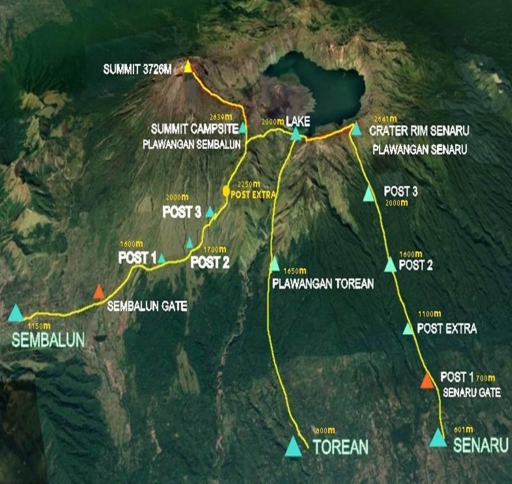
Mount Rinjani map offers a comprehensive guide to official hiking trails, important posts, and resource locations, helping hikers explore Mount Rinjani safely and in a planned manner.
The official Mount Rinjani map, available in PDF format, includes the main hiking trails on Rinjani: the Sembalun trail (East Lombok), the Senaru trail (North Lombok), the Aik Berik trail (Central Lombok), and the Timbanuh trail (East Lombok). This map details trailheads, rest/camping posts, water sources, and official routes that are safe to use. The contours and elevations of the trails are also clearly visible, helping to estimate the distance and terrain to be encountered.
The Sembalun trail is relatively long with flat terrain and passes through hot savannah, suitable for those seeking a more leisurely but longer trek. The Senaru trail is shorter, but offers steep, continuous climbs and a cooler atmosphere, thanks to its dense tropical forest.
The climb generally takes between 2 and 4 days, depending on the Mount Rinjani package and the destination, whether it’s just the caldera, Segara Anak Lake, or the summit of Mount Rinjani (3,726 meters above sea level).
The map also shows the locations of attractions such as Segara Anak Lake, Goa Susu, and the Aik Kalak hot springs.
Camping stations are located at several points, such as Plawangan Senaru and Sembalun, with natural rest areas and water sources identified by our guides.
Our guides know the water sources/springs marked at various points on the climb for hikers’ drinking water needs.
The Mount Rinjani caldera, with its beautiful Segara Anak Lake, and Mount Barujari (an active volcano) are also clearly mapped, including the location of the crater and observation points.
Symbols and contours on the map help guides and climbers navigate the terrain, determine elevation, and avoid dangerous routes.
Our guides read symbols indicating slope contours, water points, rest posts, and support structures.
Our guides read the map scale to estimate distances between posts or daily travel times.
Our guides assess difficult trail sections and foggy weather.
The best time to climb is during the dry season, from April to November, to avoid rain and the risk of landslides.
Please bring equipment such as warm clothing and a load of about 5-7 kg on your shoulders, as the terrain is quite challenging.
We provide the services of experienced local guides for your safety and to preserve the national park.
Prepare yourself physically and mentally for the challenging terrain, especially on your way to the summit and the caldera area.
A Mount Rinjani map is an essential tool containing information on routes, elevations, posts, water sources, and camping areas that every climber should have. With this map, climbing Mount Rinjani will be safer, more focused, and even more memorable, thanks to its stunning natural beauty. If you plan to climb Mount Rinjani, please contact us and adhere to the Mount Rinjani National Park regulations.
Happy climbing and enjoy the beauty of Mount Rinjani!
Offering tour packages to climb Mount Rinjani, Lombok and surrounding areas as well as organizers of group or private tour guides for all activities involving sports and adventure volcanoes complete hiking, trekking, climbing, camping packages at National Park Mount Rinjani on Lombok Island Indonesia
All above content copyright ©trekkingrinjani site owned and governed by Mr. Satya Budi since 1999. In accessing the site ©Trekking Rinjani you must agree that you are only able to download the contents for personal gain which is not commercial. You are not permitted to copy, broadcast the photos, titles, descriptions and the above material, download, store (in any medium), displays or played in public or adapt or change in any way with the content of this site is ©Trekking Rinjani with any purpose without first get written permission from ©Trekking Rinjani, many of the trekking organizer have been emulating copyrighted material that we made since 1999 by Mr. Satya Budi